


Once upon a time in the Web - Episode V
- Aug 11, 2016
- 1 min read
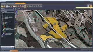
Combining expropriating processes and geographic information systems (GIS) remains a key issue for land management and property system. This demonstration examines the development of a web GIS application as part of a Land Management and Property System that helps an internal bureucracy of Public Power S.A -- Hellas (www.dei.gr).
The development of the system was based on open source software tools such as UMN MapServer for map publishing, PostgreSQL and PostGIS for the data management and HTML, PHP and JavaScript as programming languages. In addition, background processes are used in an innovative manner to handle the time consuming and computational costly procedures of the application.
Furthermore, a web map service was created to provide maps to other clients such as the Google Maps API v3 that is used as part of the user interface. The output of the application includes maps in vector and raster format, grid files that can be used in a variety desktop GIS software. Furthermore, the system can be easily customized by the final user.


![Structure from Motion [SfM] Photogrammetry for Industrial Heritage.](https://img.youtube.com/vi/gHZmoRy9Lks/mqdefault.jpg)


Comments