 Master Plan of the environmental threats of a Hotel construction site - Ikos Odissia Corfu - Greece.The construction of the "Ikos Odissia" Hotel in Corfu, Greece, marks an exciting development for the tourism industry in the region. However, every construction project, regardless of its significance, brings with it a set of environmental threats that must be addressed responsibly. This master plan outlines the key environmental concerns associated with the construction of Ikos Odissia Hotel and provides a comprehensive strategy for mitigating these threats. |  Industrial Heritage Master PlanGuardians of the past, industrial sites testify to the ordeals and exploits of those who worked in them. Industrial sites are important milestones in the history of humanity, marking humanity's dual power of destruction and creation that engenders both nuisances and progress. |  Shaded Relief Mapping |  Gratini Dam - GreeceUnderstanding the impact of dam-triggered land use/land cover change |  Expropriation Orthophoto MapThe dynamics of urban expansion and its impacts on land use/land cover change and small-scale farmers living near mining areas. |  Open Pit Mining LandUse ChangesLand use/land cover changes in the mining area of coal fields of Northern Greece. |
|---|---|---|---|---|---|
 Lignite Center of Western MacedoniaLand use/land cover change dynamics analysis in mining areas of Lignite Center of Western Macedonia - Greece. |  Vereggarria Renovation Project - CyprusDrone Mapping Photogrammetry and Orthophoto produce in Vereggarria abandonent settlement in Cyprus. |  Geological Map of Athos Peninsula |  Lignite Deposits in Megalopoli basin |  Traffic Noise PredictionPrediction, Calculation and Mapping Road Traffic Noise in Asteras Vouliagmeni Bungalows and Resort. |  Pm10 EstimationEstimate PM10 concentration due to a large renovation project in Asteras Hotels and Resort (Vouliagmeni - Greece). |
 Open Pit Mining True Orho MappingGeomatics for Rehabilitation of Mining Area. |  Potentiometric SurfacePotentiometric Surface and Water-Level Difference Maps of Selected Confined Aquifers in Northern Greece. |  Geomorphology MappingTerrain cartography as an essential aspect of physical geography. |  Geologic MappingGeological Web-Gis of Egnatia Motorway |  Hydrolithology MappingCreation of a Digital Aquifer Permeability Map for the Chalkidiki watershed in North Greece. |  Geologic MappingGeologic Mapping for water quality project. The case of Eleftheres watershed. North Greece. |
 Noise EstimationNoise Estimation Mapping due to large Renovations Project. |  Landfill 3D VisualisationIntergrated GIS, Fuzzy Logic and AHP in modelling Optimum Sites for Landfill Selection. |  Watershed Conductivity and SalinityUrban Watersheds: Geology, Contamination, and Sustainable Development |  Hazard Risk MappingIntergrated GIS, Fuzzy Logic and AHP in modelling Optimum Sites for Landfill Selection. |  Geologic MappingHydrothermal alteration zones detection in Limnos Island through remote sensing. |
Satellite Imagery
Evmolpos operates a full range of integrated and cutting-edge remote sensing technologies on land environments. Our operational capabilities include: digital orthophotography, hyperspectral/thermal imaging and GIS support services.
In addition to the collection of geospatial data, Evmolpos has developed unique software (custom based Web Gis with open source tools) and internal processes to integrate and manage differing remote sensing datasets into final products.
These products have been relied on by industry leading companies for cost-effective solutions for a range of complex applications, including: Electrical Transmission, Energy, Environment, Mining, Pipeline, Transportation and Marine.

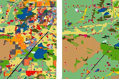
Image classification
Digital image classification techniques group pixels to represent land cover features. Land cover could be forested, urban, agricultural and other types of features. There are three main image classification techniques in Remote Sensing:
-
Unsupervised image classification
-
Supervised image classification
-
Object-based image analysis
Pixels are the smallest unit represented in an image. Image classification uses the reflectance for individual pixels. Unsupervised and supervised image classification techniques are the two most common approaches. However, object-based classification has been growing very fast lately.
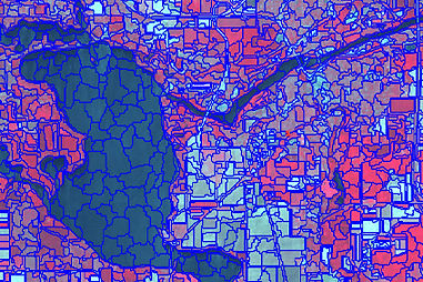
Image segmentantion
Satellite Image segmentation has a most important role to play in the field of remote sensing imaging, for effectively detecting the Surface of the Earth.
In Digital Processing, image segmentation is the process of partitioning a digital image into multiple segments (group of pixels). The goal of segmentation is to simplify and/or change the representation of an image into something that is more meaningful and easier to analyze. Image segmentation is typically used to locate objects and boundaries (lines, curves, etc.) in images. More precisely, image segmentation is the process of assigning a label to every pixel in an image such that pixels with the same label share certain characteristics.
The result of image segmentation is a set of segments that collectively cover the entire image, or a set of contours extracted from the image.
Change detection
Detection of changes in the land use occurring over time becomes very valuable information in rapidly changing environments.
High resolution digital aerial imagery can be especially useful for assets managements to identify new, modified or no longer existing objects such as swimming pools, sheds, roads. Multi-temporal Multispectral High resolution digital aerial is used to monitor environmental changes occurring over a specific period of time.
We provide custom change detection services based on our high-resolution digital aerial imagery to fit your project requirements.