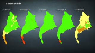
Implementation of Mapserver UMN and effective Open Source Software for spatial management of Land Ex
Geographical data services, via internet, require proper management of spatial and non-spatial data. GIS helps in effective analysis and...


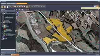
Orthophoto generation using IKONOS imagery and high-resolution DEM. Integration of digital photogram
This project describes a workflow for the DEM extraction from unrectified satellite stereo scenes, its visualization and integration in...


![Structure from Motion [SfM] Photogrammetry for Industrial Heritage.](https://img.youtube.com/vi/gHZmoRy9Lks/mqdefault.jpg)